|
Our research group wrote an opinion article that was published today in the New York Times. It summarizes Ethan Coffel's recent study showing that heat-humidity combinations so extreme that even constant sweat won't be able to sufficiently cool us down will become a reality and then a regularity by 2080 in parts of the tropics and subtropics, many of them densely populated and all of them having contributed relatively little to cumulative greenhouse-gas emissions. The rest of the world will also see sharp increases in extreme humid heat, and the resulting heat stress. Although these projections are for the late 21st century and RCP8.5, what's considered the 'worst-case' trajectory (with warming of 3.0-4.5 deg C since the 19th century), that's exactly the trajectory that the world has been on ever since the first IPCC Assessment Report in 1990. Glimmers of meaningful changes are happening, but there's still a long way to go before global emissions begin to decelerate -- and then level out -- and then drop. All the while, concentrations of greenhouse gases in the atmosphere will continue to rise.
In a long-term sense, then, the just-released IPCC report on climate changes for 1.5 deg C of warming vs 2.0 deg C is good for awareness but mostly an exercise in rearranging the deck chairs on the Titanic. In all likelihood, we'll blow by both of those targets within 30 years. Among many other things, that means there'll be a continuing need for evaluating the effects of this ever-increasing heat on health, the economy (e.g. agriculture, natural resources, tourism), and ecosystems. It would be great if this article, with its focus on awareness of the risks and its faint policy recommendations, were the last of its kind, but many more such articles will probably be necessary. Being the bearer of bad news is not a pleasure so much as a service. As a climate scientist, I got into this business because I enjoy understanding the intricate patterns, and in the absence of anthropogenic climate change there would still be plenty to study -- understanding natural variability, advancing high-resolution modeling, working on seamlessly merging climate and weather prediction. That's the positive message I try to convey when discussing my work, but that's not to make light of the very real risks that the most hard-edged aspects of climate change, such as extreme humid heat, will pose to lives, property, and livelihoods around the world.
0 Comments
I recently attended the International Conference on Urban Climate, which, quite appropriately for an event whose major themes include megacities and hot weather, was held in New York during a typically grueling August heat wave. Among the ideas and findings were a number of demonstrations of emerging research tools. Some of them represent technological breakthroughs, others approaches applied in new and innovative ways. A selection of the most exciting are highlighted in the following paragraphs. As more and more money is poured into (re)designing urban areas in ways that are climate-aware, how do we ensure that this money is well-spent? For example, a common strategy is to plant more street trees, but how many and where? The usual approaches, in increasing order of accuracy and price, involve expert judgment; a few field experiments, extrapolated to the entire city; or a series of climate-model runs differing only in the surface land cover. A way to get accuracy much more easily is to employ an algorithm that can quickly run through possibilities and select the optimum. Kunihiko Fujiwara from Takenaka Corporation discussed just such an algorithm, aimed at designing an optimal Tree Arrangement Priority map for a city. This means iterating through the steps of tree arrangement, calculation of surrounding temperatures, determination of the cost-effectiveness of the tree, and finally back to slightly modifying the tree arrangement to see if the cost-effectiveness improves.
Tianzhen Hong from Lawrence Berkeley National Lab talked about his group's development of a new feature for the EnergyPlus software program which makes it possible to simulate energy demand of every building in a city at 10-minute intervals. To do this accurately, they must take into account its occupancy, materials, geometry, and neighbors, as well as the ambient weather conditions. The underlying platform, City Building Energy Saver, allows free analysis of neighborhoods in several US cities, both as they are and with potential modifications. This tool fills an important niche, as the interactions between adjoining buildings, neighborhoods, and even cities as a whole are drawing more attention (for example, a keynote by Marshall Shepherd discussed the nascent concept of ‘urban archipelagos’, a term implying that in some areas each island affects and is affected by the others nearby). 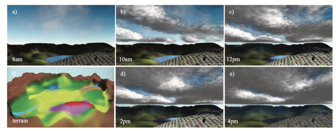 A 'digital synthetic city' with complex terrain and the output of a high-resolution weather model coupled to it. From Garcia-Dorado et al. (2017). Field campaigns are endangered. At least, that’s the sense I got from hearing several people discuss the Digital Synthetic Cities approach. A leading proponent of it is Dan Aliaga at Purdue, although it has more and more practitioners. The essential idea is to create a digital model of a city that has the same properties as a real one – the same building sizes and materials, the same thermal properties of the streets and vegetation, the same solar-radiation input – but which only exists in digital space, making it easier to study. The verisimilitude gives it a slightly uncanny movie-like or video-game-like quality, not too different from Seahaven Island in The Truman Show. Of course, creating synthetic data or a synthetic environment is nothing new, and is happening across disciplines. This speaks to the power and universality of statistics – at their core, statistics are exactly designed to serve as a layer of abstraction, to describe things such that the actual thing is no longer needed. The novelty is in the complexity and concomitant power of these digital synthetic cities to answer questions that were previously well beyond the range of feasible computation, such as understanding the causes of small-scale precipitation patterns in a particular storm. The advances this approach will bring include a newfound ability to examine details of a certain location's climate, but also to better generalize findings as new patterns are uncovered and new processes are simulated, making it easier than ever to not only say why Place A and Place B are different, but why they are similar.
A large part of applied urban climatology consists of identifying climate-related hazards for existing urban areas, and devising solutions that either mitigate the problem (“mitigation”) or increase the community’s ability to cope with it (“adaptation”). Rarely, however, do we take the evaluation back to its natural starting point — that is, the location and form of urban areas in the first place. Perhaps this is because the major aspects of cities like size and location are largely outside the control of any one generation of policymakers, so that they are essentially unchangeable, especially on the approximately decadal timescales that are relevant for most climate planning. This unchanging character means a substantial amount of lock-in of future emissions due to the development patterns that exist today (that is, future emissions even if all future development was planned to be perfectly carbon-neutral). This concept could perhaps be extended to include locked-in societal risks as well. Unfortunately, the price tag and level of political wherewithal necessary to meaningfully change these patterns are all but unachievable. In certain ways, this is a positive: strong-arming people into relocating to places of the government’s choosing, even if those places are objectively identified, does not seem palatable. What is more feasible is preventing or disincentivizing additional high-risk development, rather than attempting a post hoc ‘cure’ for poorly planned cities. As with most prevention/cure dichotomies, prevention is much easier — and given that the costs of these decisions are ultimately manifest on a societal level when they balloon to a certain size, these choices should be of interest to all.
There are several levels of bad decisions about choosing the location for a city or other new development. There are the harmless mistakes (siting Lima in the summer, not knowing about the constantly cloudy winters), the constrictions that become apparent only as a city grows to appreciable size (water availability in Cape Town), and the constrictions that should have been apparent from the very start (the smidgen of naturally high ground in New Orleans). Of course, the recent troubles with the above-mentioned places could largely have been avoided with better long-term planning, and responsibility for the crises of Hurricane Katrina and the 2016-18 Cape Town water shortage should not rest solely on the shoulders of the cities’ founders. After all, in many such cases it took centuries for the problems to reach levels where they could cause a significant negative impact on daily life. Modern-day development that expands cities, however, cannot so easily claim ignorance. Paving large sections of the Texas Gulf Coast, or building homes in claustrophobic California canyons, is enabled by the absence of open-market forces (e.g. lower-than-fair insurance premiums) in combination with a propensity to underestimate the associated risks. Harveys and wildfires, in other words, were not sufficiently considered or prepared for. Some meetings I attended last fall focused on the rapid population growth of the ‘wildland-urban interface’ and the tragedy-of-the-commons hazards and public-services demands that it raises. And that’s in the comparatively data- and resource-rich United States. Whether in the hills of Nepal or the floodplains of Nigeria, urban sprawl still proceeds largely unchecked in most of the developing world, with little consideration for or knowledge of the eventual societal-level costs when these homes are damaged or destroyed (and many of them are highly vulnerable, even in the absence of anthropogenic climate change). In these places, the residents are left destitute if climate-related disaster strikes, even if the strike is fairly routine or predictable; in the developed world, residents are financially saved but typically only by the failsafe backstop of the government, and thus any kind of development with a non-negligible chance of falling into this category is really a public concern. As with many of the most interesting aspects of urban climatology, this is where science and policy blur together indistinguishably. On the policy side, the principal question revolves around how to appropriately incentivize development that's aware of the risks and vulnerabilities imposed by its location. A commonly voiced but as-yet-undone step in this direction would be to reform government-run mortgage and insurance programs to increase the financial penalty for developing areas that are known to be high-risk. Multiple overlapping evaluations of potential environmental consequences at scales from individual homes to metropolitan areas would also be wise, particularly in cases where problems may only emerge for certain types or densities of development. These could consider multiple development options at the neighborhood scale in combination with a simple climate simulation to address questions like, for instance, whether the overall risks of flooding along a beachfront are smaller with several apartment towers or a large number of homes. Detailed climate information could be used for analysis if local high-resolution simulations are unavailable or prohibitive. Of course, historically and straight through to the present, it has often been the case that the residents of high-risk areas were forced there by circumstance and would leave if they could; this represents another necessary dimension of any comprehensive policy solution. In other words, smart development requires a true proactive dialogue among actors before major urban-planning (development, zoning, etc) decisions are made. While urban-climate tools are rapidly gaining in their usefulness for analyzing the effects of past development, it would be even more gratifying to use them strategically to help guide these kinds of choices in the first place. How important is urban climatology, really? The question seems important as the field grows in size and scope, drawing in more and more resources. While certain statistics about the urbanization of the world are now widely known (e.g. that more than half the global population lives in cities, or that megacities are growing much faster than small cities or rural areas), there is also a danger that smaller municipalities will be outshone figuratively as well as literally by the bright lights of big cities, and that other worthy climate impacts will be overlooked in the process. A post last year from Marshall Shepherd commented on one demonstrated aspect of “urban bias” in the context of forecast accuracy; specifically, he noted that weather reports in the media tend to focus on urban areas to the exclusion of everywhere else, and that this focus is disproportionate even to their larger populations. I would argue that to a considerable extent this is a consequence of media navel-gazing, a sort of availability bias. After all, urban bias makes an appearance in other fields as well — how many TV shows are set in New York City, home to just 2.6% of the country’s population? Of course, this blog being titled what it is, it’s worth noting why cities are the object of such intense newfound attention. Much of it is well-deserved, a rightful recognition of the significant concentrations of people and assets that urban areas contain; the ten largest metropolitan areas in the US produce 35% of the GDP despite having only 26% of the population. There are also an enormous variety of interesting interactions on a variety of scales, which are just beginning to be able to be studied systematically (i.e. climatologically) thanks to advances in computing power. Cities are also often positioned on rivers, along coastlines, or in valleys, adding an extra topographic level of complexity to their microclimates. As a result of all of this, climate in a large and diverse metropolitan area like New York can span a wide range of temperatures, not to mention precipitation, etc. As shown in the figure below, the annual-average temperature at LaGuardia Airport is equivalent to that in central Missouri, while the temperature in the southern Catskills is like that of Minneapolis, 10 deg F colder and 400 miles north. 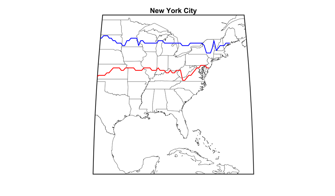 Lines marking the latitude at which the annual-average temperature equals that of the southern Catskills (blue) and of LaGuardia Airport (red), the two temperature extrema of the New York City metropolitan area. Source: Own work (based on station data and CPC gridded dataset) All fields of science seem to exhibit a tendency to stampede from topic to topic, leaving topics that are not fashionable sitting dust-covered on the side of the trail. This is unavoidable — part of human nature — but good to be aware of so that the most can be made of it in terms of building up understanding and impacts applications. For example, organizations like CCRUN have focused largely on the major cities of the Northeast, due to their having the dedicated funds and personnel for climate issues. At meetings I’ve attended there have been discussions around the possibility of working with small and medium-size cities, though here (as elsewhere in the country and indeed the world) such work is hindered by the inherent difficulties of scale, the greater number of municipalities and their smaller discretionary funds being chief among them. While 55% of people currently live in cities, only 23% live in cities of at least 1 million. In fact, in 2030 rural areas will still account for 40% of the global population. An additional positive outcome from the push to improve urban climatology would be a conscious downward movement of resources and methods to these smaller localities. Whether by direct focus or extrapolation from results for larger places, small cities, towns, and villages deserve to not be forgotten even in an urbanizing world.
|
Archives
September 2023
Categories |
 RSS Feed