Global Analysis of Humid-Heat Processes
Raymond, C., Matthews, T. K., Horton, R. M., Fischer, E. M., Fueglistaler, S., Ivanovich, C., Suarez-Gutierrez, L., and Zhang, Y. (2021). On the controlling factors for globally extreme humid heat. Geophysical Research Letters. https://doi.org/10.1029/2021gl096082
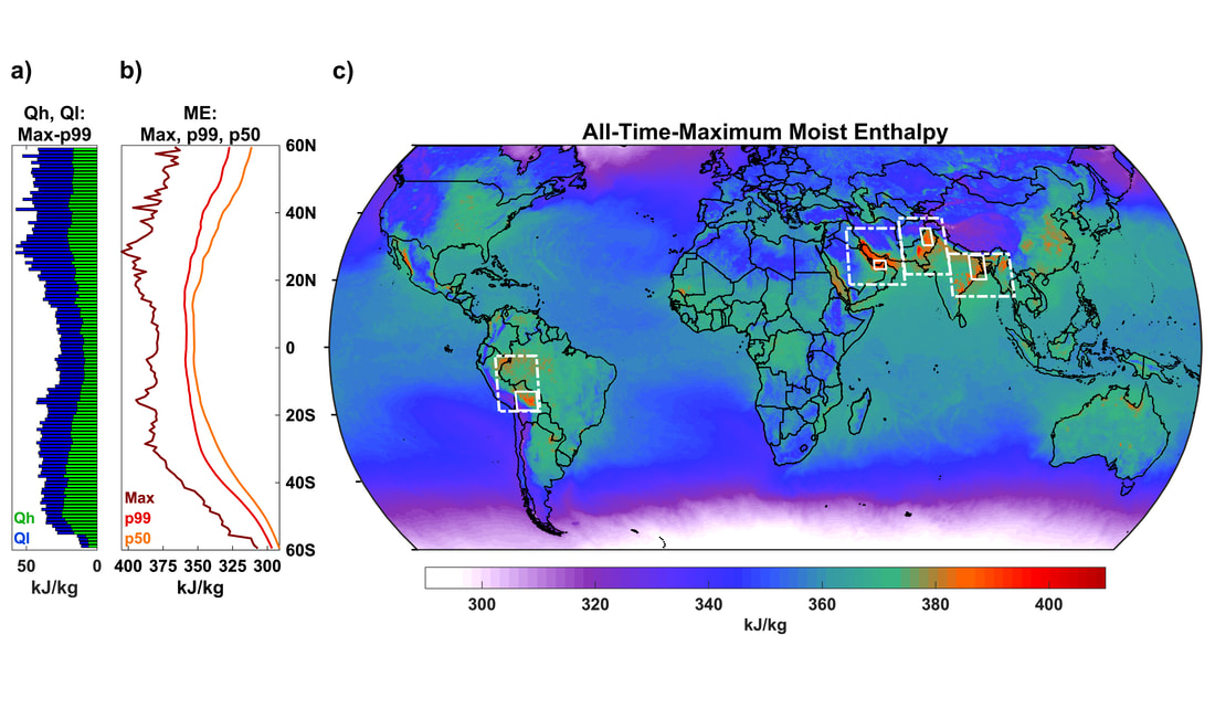
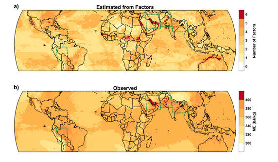
We analyzed the geographical and meteorological factors that shape the location and magnitude of the most severe humid heat on Earth. Considering ERA5 reanalysis, supplemented with several other datasets, we focused on four regions and found that during extreme humid heat events they share two key characteristics: an absence of deep convection and a presence of abundant low-level moisture. These broadly explain both latitudinal patterns as well as specific longitudinal hotspots, and proxies for them can reconstruct with a good degree of accuracy the actual spatial pattern of humid heat (lower right figure). However, across regions there are important differences in how humid heat extremes are achieved -- for example, whether moisture primarily originates from the ocean or land surface, whether topography aids in producing a stable shallow boundary layer, and whether the most severe events are relatively dry or humid. Such wrinkles motivate future work. Our study provides a first global-scale theory for understanding where extreme humid heat is most severe, and a sampling of the regionally distinctive combinations of processes through which it preferentially occurs.
Perspective Article on Connected Extreme Events
Raymond, C., Horton, R. M., Zscheischler, J., Martius, O., AghaKouchak, A., Balch, J., Bowen, S. G., Camargo, S. J., Hess, J., Kornhuber, K., Oppenheimer, M., Ruane, A. C., Wahl, T., and White, K. (2020). Understanding and managing connected extreme events. Nature Climate Change. https://doi.org/10.1038/s41558-020-0790-4
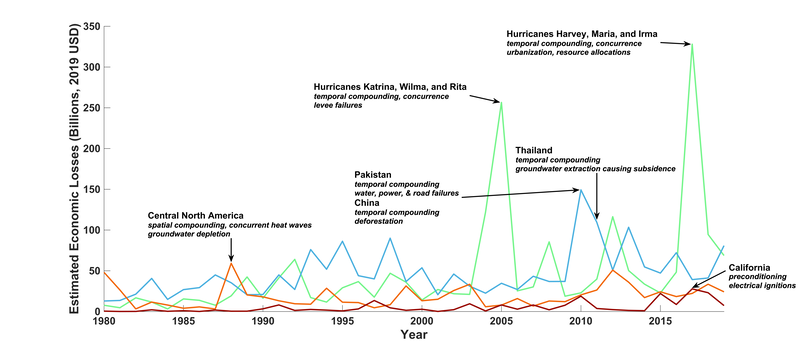
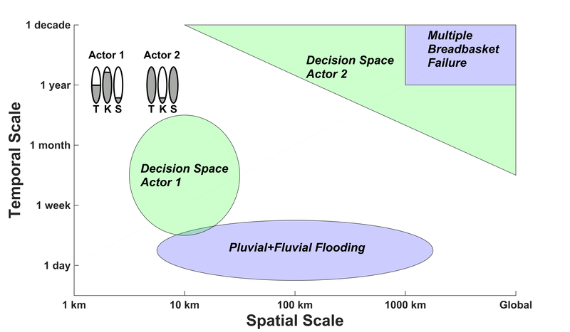
We described how the largest impacts from extreme climate events can often only be understood through consideration of the interactions of the events with human decision-making. Decisions and political/legal/cultural structures can unintentionally amplify impacts, such as when the response to one event hampers the response to another, or when multiple geographically distributed components of a system (e.g. the global food system) are struck simultaneously in a way that could have been anticipated. Through detailed description of such scenarios and the state of knowledge and practice surrounding them for five key sectors, we summarized current approaches and desired areas for improvement. Basing our proposals on a clear-eyed picture of data limitations and of the operational constraints faced by practitioners, we also recommended principles for improving the coordination between climate scientists and specialists in various other disciplines that is essential to developing appropriate preparations for the more-severe connected events of the future, including those outside the bounds of historical experience.
Global Survey of Extreme Humid Heat
Raymond, C., Matthews, T. K., and Horton, R. M. (2020). The emergence of heat and humidity too severe for human tolerance. Science Advances, 6, 19. https://doi.org/10.1126/sciadv.aaw1838
We conducted the first comprehensive survey of humid heat using weather-station data (as opposed to reanalysis datasets or historical climate-model runs). A large portion of our efforts was devoted to extensive quality control, as reflected in the final dataset, available upon request. We found that at subdaily timescales global maxima are significantly higher than was previously known, and have in a few cases briefly exceeded the human survivability limit of about a 35C wet-bulb temperature. These exceptional values are concentrated along subtropical coastlines (the Gulf of California, Red Sea, and Persian Gulf in particular), as well as the Indo-Gangetic Plain of South Asia. Globally, there are also strong trends, with extreme humid heat overall more than doubling in frequency just since 1979.
Regional Analysis of Extreme Heat Along the Eastern-U.S. Coastline
Raymond, C., and Mankin, J. S. (2019). Assessing present and future coastal moderation of extreme heat in the eastern United States. Environmental Research Letters, 14, 114002. https://doi.org/10.1088/1748-9326/ab495d
We investigated the sometimes-subtle temperature difference between coastal and inland areas of the Eastern U.S. We found that in summer months, this 'coastal cooling' averages about 2C (over a band ~50 km wide) in most regions, but more like 4C in Texas and in Northern New England. These differences decrease from May to September, especially in the north. Downscaled climate models, even those with spatial resolutions comparable to the observational data that we used, underestimate this cooling by 50-75%. Looking forward, these model errors cause a relative overestimate of future population exposure to extreme heat within about 10 km of the coast, where the cooling effect is (and will likely remain) strongest. Population densities are high there, especially in Florida, making even small sea-breeze decreases in extreme heat matter.
Regional Analysis of Extreme Humid Heat
Raymond, C., Singh, D., and Horton, R. M. (2017). Spatiotemporal patterns and synoptics of extreme wet-bulb temperature in the contiguous United States. Journal of Geophysical Research: Atmospheres, 122. https://doi.org/10.1002/2017jd027140
We produced the first comprehensive regional analysis of the patterns and meteorology of humid-heat extremes in the U.S. Through development of a new methodology to decompose temperature and moisture contributions, we found that these are driven primarily by temperature anomalies in the cooler and wetter parts of the country, and primarily by moisture anomalies in the hotter and drier parts of the country. We also found significant potential predictability contained in preceding sea-surface temperatures and wave-activity fluxes. Contrary to initial hypotheses, for most U.S. regions SST anomalies in the central Pacific are most closely related with humid-heat extremes, much more so than SSTs just offshore.


