UPDATE 2, 5/23/15: This post was originally published on May 7, at which point winter already seemed distant here in New York City (where the last frost was Apr. 1). That was not the case, however, along the Front Range in Colorado, where Boulder and Denver received about 4.0" of additional snowfall on May 9 and 10 — in the case of Boulder, that was enough for it to leapfrog Buffalo and take 4th place. In combination with Salt Lake City's 2nd-least-snowy winter, this also pushed the Denver/SLC snowfall ratio further into record territory (to 3.75). The two cities have nearly identical averages, and the previous range was approximately normally distributed about 1.0 with extrema of 0.33 and 3.15. In addition to Lowell below, several more revisions have also been made, adding or subtracting several tenths of an inch. The most relevant to the standings was Syracuse's gain of 0.1" (from 6.1" to 6.2" on Feb. 19), good for 119.8" total and sole possession of 2nd place. South Bend and Erie also each gained 0.2" via retroactive corrections. The statistics and standings have again been updated accordingly.
UPDATE, 5/18/15: Patrick DeCoursey at the Golden Snow Globe site noted that revisions to the snowfall amounts on two days in March have resulted in Lowell gaining 2.0" and jumping into first place with a new total of 120.6". Such revisions are not altogether rare given the dated procedure in many cities whereby the field observer enters the day's reading by phone as well as jotting it down on paper; in the lull after the winter has passed, the two records are then compared. Patrick explains the details of the Lowell revision here; essentially, he inquired about it and spoke with a National Weather Service meteorologist who confirmed that there had been discrepancies, and that the paper version is treated as the master copy. Other than the remarks on the winners, the below commentary remains valid (and the statistics have been updated).
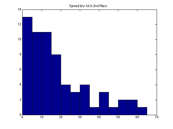
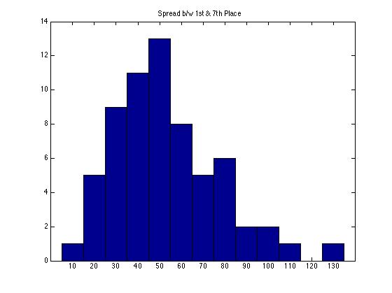
This first year of calculating the snowfall race among U.S. cities with populations >100,000 proved to be an unusually interesting one. From the final update posted on the Recent Weather page, we see there was a tie for first place between Syracuse and Worcester. Going back to the race's start in 1951 (link toward bottom of RW page), when perennial-contender Syracuse's airport weather station came online, a tie for first has never happened. The lefthand figure below shows the distribution of margins of victory over the 64 years from 1951-2014; the previous closest race was decided by 0.5" (between Rochester, NY and Erie, PA in 1999), and many are decided by 15" or more. However, as befitting a race with 64 contestants and finite measurement precision, high-level ties have happened in the past — for example, one for second between Anchorage and Syracuse in 2008. In the righthand figure, we see that the spread between 1st and 7th places this year was also the narrowest on record, with only 10.0" separating Lowell from Boston, versus the prior minimum of 13.6" (the intermediate spreads were record-setting as well). Despite finishing 6th, 7th, and 8th respectively, Erie, Boston, and Rochester NY can take solace in the fact that they finished with the most snow of any cities in those places in the history of the race.
Speaking of Anchorage, it was a complete no-show in this year's race. With only 25.1" against an average of 74", Anchorage set a record for least snowfall, as did Provo, UT which received just 21% of its usual 53.6". These observations fit the overall pattern of a low-snow winter in the West and Midwest except along the Front Range in Colorado (see map below). Snowfall amounts were mixed but generally near average across the Great Lakes snowbelt, while the third major region, the Northeast Corridor, saw heavy snow due to a series of (well-publicized) storms in its northern half in late January and February. This can be seen in the chart below the map. What stands out there is how the cities in the lead at any given point are rarely the ones making the news; for instance, Buffalo trailed or was neck-and-neck with Erie throughout November and December, while aside from the major Northeastern storm in late January that brought Massachusetts and New Hampshire into the running, the subsequent storms piled up snow no faster than did lake-effect events in the Great Lakes. Perhaps it is possible to devise a formula to estimate media attention as a function of population affected and abnormality of the conditions, rather than their absolute magnitude. Worcester's 119.7" was nearly double its average and good for 2nd all-time, and Boston's 110.6" was a record (as was Lowell's 120.6" and Providence's 76.2"); meanwhile, Syracuse's 119.8" was a notch below its average of 122".
View US Cities >100,000 2014-15 Snowfall Rankings in a full screen map 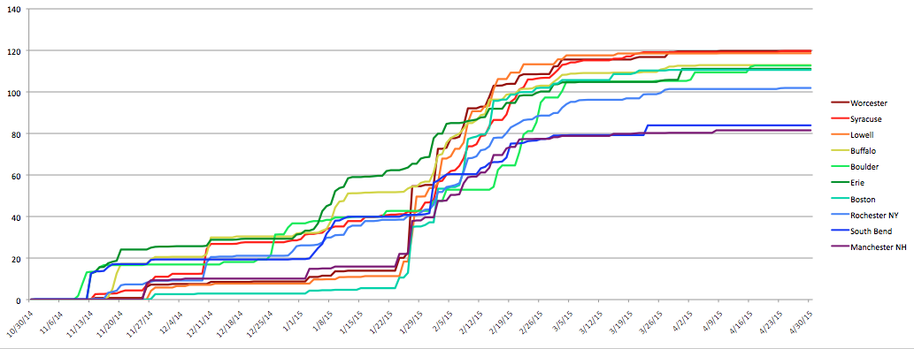
Besides the closeness, this year's iteration was notable as a departure from typical regional patterns. In this, it was a sharp contrast from recent years. In 2011 and 2014 the Great Lakes snowbelt cities ran away with the contest (particularly Syracuse in 2011, with a margin of victory over 50"). 2013 saw a relatively close race with Boulder, Syracuse, and Worcester finishing 1-2-3, and in 2012 persistent warmth in the East led to a low-scoring grudge match for third place behind Anchorage and Boulder. Many cities saw record or near-record lows that winter, including Boston at just 9.3". 2015 was unusual in that it had in Lowell the first champion from the Northeast Corridor. Indeed, a Northeast city has placed even second only four times previously, with Worcester carrying the flag in each case. Most other years the Great Lakes snowbelt has dominated the top three positions, occasionally with Western cities nudging their way to the top. Only twice in 65 years have the Great Lakes been shut out of the top three entirely: 1983 (Provo-Minneapolis-Anchorage) and 1995 (Anchorage-Boulder-Salt Lake City). This year's storms being centered on New England resulted in a much larger differential across the Northeast Corridor than usual: climatologically Boston receives 44" and Philadelphia 22"; this year those figures were 110.6" and 27.0". These storms doubtless also helped Mt. Washington vault into first place in the all-station race (also on the Recent Weather page), which is typically dominated by big Western ski resorts — many of which struggled to match even hills downwind of Lakes Superior, Erie, and Ontario. While the U.S. is certainly capable of large seasonal-snowfall totals (witness the world-record 1,140" received at Mt. Baker, WA in 1998-99), this year the international crown is ceded, at least in the universe of sites with daily manual measurement, to the resorts of Mt. Myoko in Japan.
0 Comments
Leave a Reply. |
Archives
September 2023
Categories |
 RSS Feed